Infinity Highway Opens
January-February 2018
Infinity Highway Opens
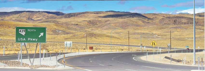
USA Parkway links two major highways and opens a chapter of Nevada history.
BY DALE BEESMER
In 1928, some $9,000 in cash, $8,000 in gold, and $20,000 in bonds and traveler checks were robbed from a bank in Virginia City. The two thieves fled east and down the Clark Road toward the town of Ramsey, and reputedly buried their loot somewhere along the way. They were caught and told the authorities where it was buried, though when authorities went to recover it, they claimed they couldn’t find it. The robbers led them to the site, but the loot was nowhere to be found. A third party may have beaten them to it, or the bandits may have been in the wrong spot. However, it just may be buried under the new USA Parkway.
The recently completed parkway establishes a 19-mile long, 4-lane state highway—State Route 439—north to Interstate 80 and south to U.S. Route 50, just west of Silver Springs in northern Nevada. Along this new route, travelers pass through an area seldom visited. Privately held land and limited access have kept this area that crosses Lyon and Storey counties out of public view, but that’s all changed now. The region contains the remnants of a historic mining district and connections to some colorful events and persons from Nevada’s past.
A VIEW FROM USA PARKWAY
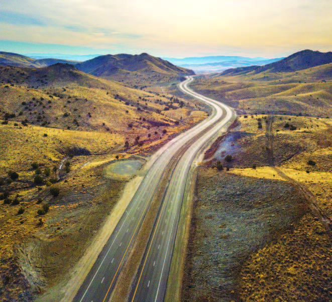
 USA Parkway begins in the north at what was once the James Clark ranch, which supplied hay and potatoes to Virginia City during the Comstock days; it then became a railroad station and post office stop on the transcontinental railroad. It was also known as Clarks Ranch, Clark Station, Clarks Siding, Clarks, and Clark. From here the first six miles of the parkway were constructed and paved by the Tahoe Reno Industrial Center (TRIC) years ago as part of its infrastructure. Within the first mile is Electric Avenue, which leads to the Tesla gigafactory. In 2014, Tesla purchased 1,000 acres in the park and its new battery production plant lays claim to the world’s largest building at 10-million square feet. The next few miles travel through the industrial park past other well-known warehouse namesakes, such as Walmart, Amazon, Zulily, and tech giant Switch. At approximately six miles south, after cresting a long hill and dropping into a prominent valley—known as the Comstock Meadows—it is reported that Google has purchased 1,200 acres here for a future data center. Looking to the southwest along this stretch, through a canyon you’ll see the enormous defunct leach pad of the Gooseberry Mine.
THE WESTERN NEVADA GOLD PROJECT
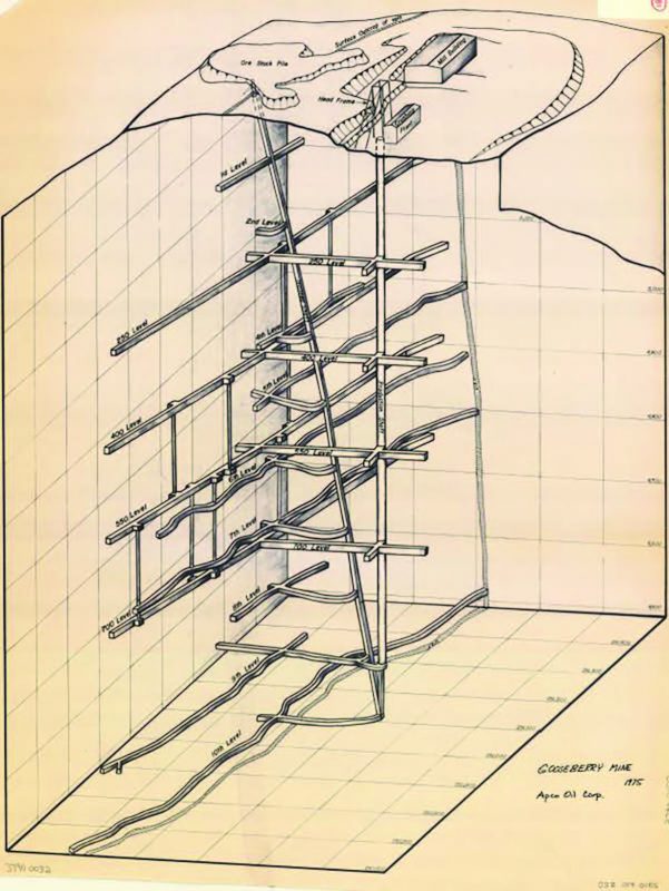 In the 1980s, Asamera Minerals—a Canadian-based gold company—was exploring 160 square miles of property they purchased from the Curtis-Wright Corporation—an area covering more than half of Storey County and a number of adjoining parcels in Lyon County. Their property also included a gold and silver operation, the Gooseberry Mine. Gold and silver were discovered in a vein at the surface in 1906, and it eventually was developed to a depth of 1,450 feet with more than 9,000 feet of horizontal drifts on several levels. Asamera sold the mine and all its land in 1990, though the Gooseberry mine continued till 1998 and was eventually foreclosed on.
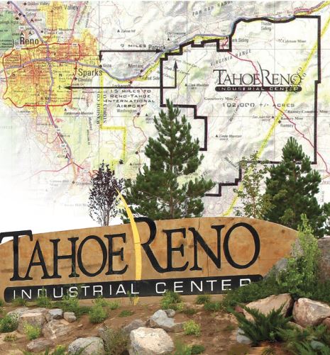
This huge parcel of land was eventually sold to the South Meadows LLC, which is now is the TRIC. At approximately nine miles south, after a winding climb, the highway begins its descent to the Storey-Lyon County line, which is also the property boundary line of the TRIC.
In this area is a former mining district known as San Juan Hill. To the west there is a small pine forest with some trees up to 100 feet tall taking advantage of the altered andesitic soils; they are very out of place compared to the traditional juniper and pinion pine of the surrounding area.
THE RAMSEY MINING DISTRICT
After passing the county line, the evidence of former mining efforts and explorations begin to reveal themselves. This area is known as the Ramsey Mining District in Lyon County. The discovery and promotion of the district was made by two brothers from Goldfield—Thomas and Braden Ramsey. On a reconnaissance trip in 1905 they prospected the area and brought samples back to Goldfield for assay. Some samples had promising results and the brothers continued their trade of setting up claims and town sites for sale. A survey map of the Ramsey district in 1907 depicts more than 189 claims and townsite lots, surveyed and platted. Promotional postcards were mailed, ads were placed in the “Los Angeles Times,” and a write up was even featured in the historic Goldfield Nelson-Gans fight program of 1906 about the Ramsey mining district, its recent discoveries, and how it may become Nevada’s next Comstock Lode.
Maynard Dixon Visits
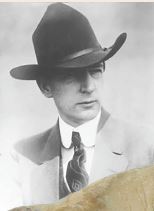 In 1923, famous western artist Maynard Dixon must have ventured from his stay at Lake Tahoe for a visit to the Ramsey Comstock Mine. An oil painting titled “Old hoist, Ramsey Mine, Ramsey, Nevada” was painted in 1927. The painting depicts the Ramsey Comstock Mine mill frame and tailings from a spot below the mill.
THE RAMSEY COMSTOCK MINE
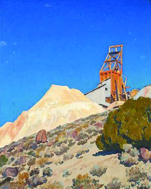 The Lucky Boy Claim at the “Discovery outcropping” would turn out to be the only viable operation of this short-lived mining district. The prominent tailings and mine workings of the Ramsey Comstock Mine can still be seen on the east side of the highway just south of the Storey-Lyon County line. Look a little closer, and the outcropping is still visible up and behind the tailing piles (and behind the hoist in this 1927 mill picture). This was coveted as the source of the high-grade mineral assays and promoted as “the largest deposit of uncovered gold yet discovered in the world.” In 1909, Nevada notables George Nixon and George Wingfield financed the construction of the mill at the Ramsey Comstock Mine.
No records were kept of the district’s early years of production, but later records indicated the production at the Ramsey Comstock Mine totaled less than $400,000 in its last decade. The mine’s final operator—the Lahontan Mines Company—closed it for good in 1940.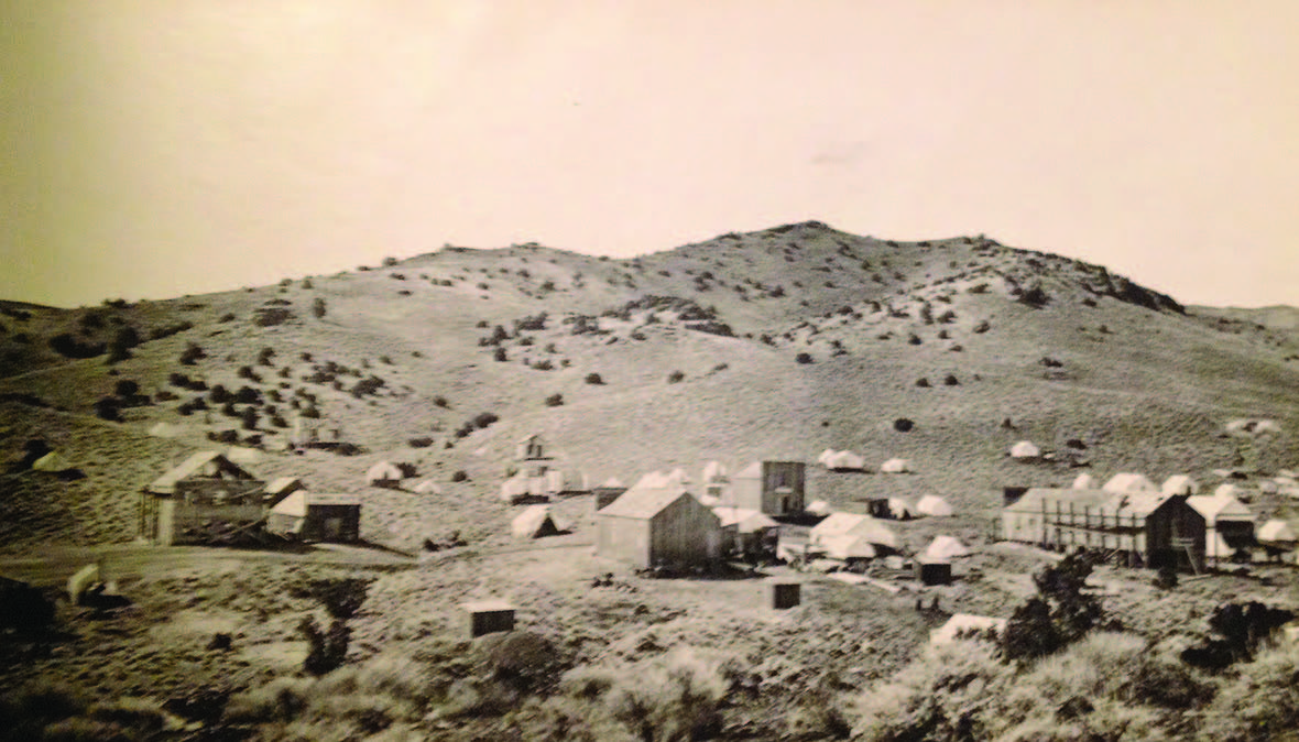
THE RAMSEY TOWNSITE
Just south of the Ramsey Comstock Mine in a narrow canyon running westward is the former Ramsey townsite. At one time, Ramsey boasted more than 600 residents, six saloons, four stores, two restaurants, a hotel, an assay office, and a newspaper, the “Ramsey Recorder.” A post office was in operation from the years 1906 to 1913, and by the 1920s only a handful of people remained to work at the Ramsey Comstock Mine. Today nothing of the town remains except some rusting cans and broken glass.
THE END OF INFINITY
Leaving the Ramsey Comstock Mine, through the heart of the Ramsey Mining District reveals numerous tailing piles and prospects peppering the hills. The mountains make way to more open terrain further south and the last few miles to the junction of U.S. Route 50 at Silver Springs. At Highway 50, a new roundabout marks the end of this north/south parkway.
It is at this terminus, in the vicinity of a former emigrant trail station—Stockton Well—that the Ramsey brothers and their grubstaking contingent made their way north from Goldfield more than 120 years ago. This new highway link lets modern-day travelers revisit an interesting chapter from Nevada’s boomtown days.