Yesterday: Nevada Tourist Roads are Calling You
February – April 2022
This story originally appeared in the January/February 1946 issue of Nevada Highways and Parks.
Americans have at last emerged from the A-card era and entered the “fill ‘er up” stage. The Great War has ended. Gas rationing is out, tires are much easier to get with good prospects for future supplies. New cars, with trimmer lines and post-war styles, are beginning to show themselves on the highways. Tourists are reviving and brushing off their dreams, scanning maps, inspecting lights, looking hopefully at the tires, and cocking their ears to the rhythm of the motor. In leisure hours, during the long winter nights many Americans are planning itineraries, speculating on desirable stopping places, wondering about roads, and even arguing, perhaps, in a friendly fashion, where they shall journey on their first postwar touring trip. By June the Nation’s highways will be well crowded with rolling vehicles, filled with travellers going places, for visits away from home. An army of journeying tourists will be on their way to learn how their relatives and friends, or fellow citizens in distant parts of the country, have weathered the storms of wartime, to revive old friendships and to establish new ones, and also to satisfy an urge to “see the country” for a change of daily routine. Highways are again the paths which draw Americans closer together and make them realize, and no double appreciate, the magnitude and wonders offer beloved country, and to enjoy the blessing of peace.
All signs indicate that the entire Nation is preparing to travel in ever increasing numbers. With such a prospect in view Nevada citizens are getting ready to welcome and entertain a greatly increased number of travelers, who will journey over the highways of our State. At the very outset we should like to assure prospective visitors and tourists that our highways have come through the war in good shape and can, very adequately, accommodate the expected increased travel.
We do not wish to imply that our highways are perfect, for they have been through the rigors of four years of wartime travel. Lack of personnel, extra heavy travel in certain sections, equipment and parts priorities, and curtailment of construction activities during those trying times were major obstacles which made it impossible to carry out a 100 percent maintenance on all segments of our road system. The “shooting war” has stopped, however, and Nevada, like the other States of the Nation, is gradually adjusting itself to the strange, but very welcome, peacetime conditions. We in Nevada are working diligently to solve every problem, so far arising in post-war times, whether it be travel, industrial, social, or economic.
Our highways have had considerable wear during the war era. Fortunately, however, the pre-war construction programs and policies were such that our roads were built to a high standard and as a result they have weathered the storm of war in a surprisingly favorable condition.
There are short stretches, here and there, which do show deterioration. Some chuck holes, ragged shoulders, crumbled surfaces, and asphaltic waves, have developed, but to a minor degree. That was to be expected, and particularly it would be apparent in our western States where highways stretch for long distances across sparsely settled country and heavy maintenance with long patrols are necessary.
When one remembers that the geographical area of Nevada approximates 110, 00 square miles, with a population of only 130,000, and that the highway system aggregates approximately 3,200 hard surfaced miles, it is not hard to realize that the maintenance job, even in normal times, is a major one.
Nevada’s Department of Highways, even with curtailed personnel and low priorities for new equipment was able, through persistent effort, to maintain a degree of adequacy in maintaining its transcontinentals. Because of that fact, we are able to frankly inform tourists, who plan to come to Nevada this year, that our highways are safe for reasonable driving. We shall be happy to receive you as guests and visitors and assure you that what Nevada has to offer in the way of attractions is of a most interesting character.
We have a broad selection of transcontinental routes over which you can travel through Nevada. You may come in over 40, 50, 91, 6, 93, 95, or 395. It is possible for you to spend a day, or several days, or weeks, if you wish, in comfort, and see in greater detail some of our cities and towns, our extensive agricultural areas and many of the striking natural phenomena which exist here in this western country. In addition to that we have liberal laws, our people like to enjoy life in a sensible manner, and outdoor recreation is one of our hobbies, both summer and winter.
We have numerous mountains and valleys, some forests, interesting lakes, picturesque streams, colorful towns and expansive ranches, all of which we are anxious to show you. We are firmly convinced that if you

come you’ll like our people, and our State, and you will enjoy the many diversified things which nature gave us on a gigantic scale. We should like also to show you the cultural progress we have made, through our own efforts, from the days of the pioneers down to the present time. Nevadans are proud of these things and we are anxious to share them with you.
Because we realize that travellers will demand good roads, and good stopping places for shelter and accommodations, and good places to eat, Nevada citizens are making every effort to serve your needs, so that you will derive the greatest measure of pleasure and comfort from your trip into our State, and that you will want to come back again, or that you will tell your friends and they will want to visit our State.
So that we can do our share in attaining this objective the Nevada Department of Highways plans a construction program on its highway system which will make our roads even better than they were before the war, and we shall have them in good condition for the post-war travel.
Nevada’s post-war construction program for 1946 is already under way. Plans and specifications have been completed and the operations have been set in motion. Our first post-war job was contracted in December. Under the present schedule there will be approximately $5,500,000 in road contracts awarded for projects to be completed this year. Many stretches of our highway system will come under this improvement program. Some segments will get new construction and new alignment, some will be worked over and widened, others will have improvements such as bridges, new surfacing, wider shoulders, four-lane highways, where traffic justifies, and elimination of all grade crossings. We are also keeping in mind the safety factors. Stripe lines, road signs of caution and warning, guard rails at appropriate places, reflectors along curves, and all other accepted safety signals are being renewed, and installed where needed.
We definitely assure the travelling public that wherever detours become necessary while construction work progresses they will be made as short and travelable as possible. The detours will also be given oil treatment so that you won’t have to drive through clouds of dust, or holes of mud. In fact, the program definitely calls for the construction work to be carried out in such a manner that the least possible delay for travellers will occur on any route affected. These protective measures will afford to the traveller the opportunity to make good time and distance with minimum delays.
While Nevada’s highways took quite a beating during the war period, from heavy military and civilian traffic, in spite of the gas rationing and tire shortages, there are no major breakdowns on any highway in our entire highway system.
Recent inspection trips by State Highway Engineers show that while in some places short stretches of deterioration have occurred, these are not serious and on the- whole we can justly say that the roads even today are in excellent condition. We know, however, that improvements will have to be made, to maintain them at a high standard for the years to come and that these improvements are now in order. Then again highway construction indicates the progress of a State.
Federal highway funds, together with our matching State funds, are available for use, personnel has been increased, many of our former employees who went into the various services of our Nation are now returning, and conditions generally are auspicious for us to carry out rapidly the road program. Just by way of mentioning, 180 of our highway department pre-war personnel heard the call of the Nation and gladly gave their services. Nine of those fine boys will never come back to resume their work in the department. In memory we respect them and reverently place their names on our scroll of perpetual honor. We shall miss them. God grant they may rest in peace. Those few places where deterioration has occurred will receive our first attention and shall be put in tip top condition as soon as possible. We realize that for four long years the urge to travel by our citizens has been pent up through wartime restrictions, and now they want to get out and roll over the highways. And they will want good highways. That is our objective-good highways. Nevada did improve several units of the highway system during the wartime. Some improved segments were needed essentially for army, navy, and air force travel, and we put those segments in excellent condition. Despite the heavy traffic, they have stood up well and are now ready to serve civilian travel.
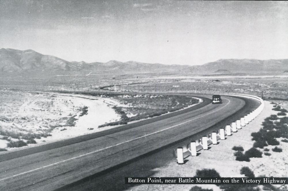
For instance, on highway US 40 (The Victory Highway) which the army early in the war designated as one of the prime strategics through the State, several major construction projects were completed since 1941. As a result the entire stretch of Route US 40 , from the great bomber base at Wendover, Utah, on our east boundary line westward to the California line, a distance of 41 7 miles, you’ll find travel a pleasure over a 24-foot road width, with 4-foot improved shoulders on each side, and a smooth hard travelling surface. That applies to the highway for 95 percent of its length. Near Battle Mountain the road narrows for a short distance to a 20-foot width, but is easily travelable and good, with no heavy grades and only a few wide curves. This stretch probably will be improved this year.
On US 91 (The Arrowhead Trail), our southern route, which serves the important Las Vegas and Boulder Dam areas, we brought segments of that highway in excellent shape to accommodate the large volume of military travel. There were several air force bases in the Las Vegas vicinity, and also a gunnery training camp nearby, which brought many thousands of officers and men into the area. Through road improvements made, those service men had easier access to and from the base and the city. This US 91 also serves as an arterial for motor travel west into the metropolitan areas of Southern California.

The army, navy, and air forces, during wartime, needed lots of magnesium metal which Nevada was able to supply. At Henderson, a new city between Las Vegas and Boulder City, a gigantic plant for the production of magnesium metal was constructed and operated through most of the war period. Production at Basic Magnesium Inc. meant thousands of additional workers for that district. To take care of the traffic volume, Nevada Department of Highways constructed a four-lane divided highway to serve personnel, buses, and trucks between Las Vegas and the plant. The wartime magnesium plant has discontinued the manufacturing of magnesium, but many units of its buildings have been taken over by individual manufacturing enterprises for post-war industry. These enterprises are taking advantage of the low cost power from Boulder Dam. Future operations at this gigantic industrial center seem more definitely assured than anticipated.
To supply Basic Magnesium Inc. plant with raw ores from the mine required a long haul. Specially designed trucks were built and placed in operation for transporting the magnesium oxide from Gabbs, site of the mine in northwestern Nye County, 225 miles away. These heavy trucks required good highways, and it was necessary to keep U S 95 ( The Bonanza Highway) in good condition. We are proud to say that not one truck was delayed because of highway failure. This north and south arterial, 95, comes into the State south of Searchlight and traverses northward to Oregon. Near Boulder Dam, close to its course, is located Boulder City, the administrative center for the entire Boulder Dam works. Las Vegas, likewise, is served, and north of the “Last Frontier” city, about 15 miles, there is a junctioning hard-surfaced road which affords access to Charleston Park, southern Nevada’s recreational playground. Travelling on up through the State past colorful mountains, and through picturesque mining camps, Route 95 serves Goldfield and Tonopah. These two towns came vigorously to life during the war. A bomber base near Tonopah, an early day rip roaring silver camp, brought thousands of military personnel into town, and overcrowded housing facilities. This condition was relieved to some extent by the proximity of Goldfield, 25 miles south. Desert commuting was inaugurated. Goldfield, a wide-open Nevada gold camp during pioneer days, came into being shortly after Tonopah’s discoveries. Both camps were in the peak of their production during the early years of this century. Since departure of the military personnel from the vicinity, both camps are taking up mining activity again.
Farther north on 95 the ammunition naval depot at Hawthorne assumed great importance during the war, and the town experienced a very large increase in population. North of Hawthorne after route U S 95 skirts beautiful Walker Lake for 20 miles it enters the rich and thriving Yerington district, with Mason and Smith Valleys nearby. Ranching and cattle and sheep raising are conducted on a large scale in that district.
Paved Route 95 then serves Fallon before coursing on to Winnemucca, then through Paradise Valley, and eventually Oregon.
US 50 ( The Lincoln Highway) is an eastwest arterial through the State. Coming from the Placerville gold mining region in California, 50 follows the shores of beautiful Lake Tahoe, then drops down on a long winding grade into the Carson Valley, serves Carson City, the State capital, before continuing east. Fifty-six miles from the State capital the very important Lahontan Reservoir, and the Fallon reclamation area, under the Newlands Project, are served before the broad, black road band rolls over the desert country to Austin, then Eureka, two reviving mining camps. Austin and Eureka are interested in renewed mining activity following some very sensational discoveries of lead, zinc, and silver in their vicinity. This route 50 also serves the Fallon Naval Air Base.
For 320 miles east of Carson City, Route US 5 0 climbs over mountain passes and crosses valleys before reaching the great copper district of Ely. After Ely and McGill the road runs northeast to Wendover.
US 395 (The Three Flags Highway) constitutes a very important north-south arterial in western Nevada. During the war it served the Reno Army Air Base, where huge Air . Transport Command planes, of the C-54 and the C-47 types, were stationed, handled by thousands of training personnel. This paved highway also affords a direct outlet from western Nevada to the Los Angeles metro-politan district. Many large and important cattle ranches, and agricultural acres, in western Nevada, as well as farming communities like Minden and Gardnerville, look to this highway for their highway transportation service. While its length, through our State, is less than 100 miles, its rating is of the highest importance. Travel between Reno and Carson City uses US 395.
US 6 (Theodore Roosevelt Highway) strikes east and west, entering the State at Baker, east of Ely. Its course through the desert from Ely to Tonopah lies over mountainous areas of striking ruggedness, with long stretches of open, but colorful and interesting country. After leaving Tonopah, US 6 enters into California over Montgomery Pass, where snows seldom block travel going into the Bishop district.
US 93 (The International Four States Highway) in eastern Nevada, was not called upon to carry the heavy traffic burden which some of our other routes did during wartime. As a consequence that excellent highway did not need special maintenance. Curtailed traffic also conserved the surface and left it in excellent condition. 93 serves Ely, the mammoth copper pit at Ruth, mines around Kimberly, and then the huge processing mills in the McGill section: US 93 is a direct route running from Idaho down through Ely, Pioche, Caliente, co the Las Vegas region. At Pioche there are large and important lead and zinc deposits under process of development. Vast in extent they will afford industrial activity for years to come. Caliente, a division point of the Union Pacific route, had its extensive rail yards busy 24 hours a day, moving important passenger and freight loads between Salt Lake City and the coast in the Los Angeles district.
If you’d like to view a beautiful lake surrounded by dense forest in the high Sierra Mountains, we mention Lake Tahoe; if you want to see colorful, rugged cliffs, and fluted walls, we remind you of Cathedral Gorge, in eastern Nevada between Caliente and Pioche; if you get a thrill by entering large caves with exquisite natural beauty, be sure to visit Lehman Caves in White Pine County; if you are interested in the broad expanse of western cattle ranges, spend some time in Elko, Pershing, or Humboldt Counties. While you’re in Elko County, you will probably see the lofty, rugged peaks of the Ruby Mountains. Then if you travel north, from Elko, the Rio Tinto Copper mine, the Wildhorse Reclamation Dam, or the Owyhee Indian Reservation, will capture your interest.
If you want co go fishing you can select either a mountain stream or a lake. The Truckee, The Walker, The Carson, The Humboldt, all lure river fisherman in season. Lake Tahoe, Pyramid Lake, Walker Lake, Lahontan Reservoir, and great artificial Lake Mead beckon for some good lake fishing.
Boulder Dam symbolizes the industrial phase of Nevada life. Gigantic electric power supplies are generated at this reclamation project. The dam backs up the Colorado River for 115 miles, and incidentally provides flood control for the great Imperial and other valleys below the dam. It also impounds water which can be used to irrigate the parched desert acres nearby, and affords a water way into the Grand Canyon.
Our highways serve all of these places, and give access to many more which we have not mentioned. Gradually, year by year, we are spreading our our system of highways and reach into sparsely travelled and little known places to make them accessible co the travelling public.
Nevada welcomes you to come and see our State this year. If you can’t make it this year, be sure to put it on the must list the first time you plan a western itinerary. You’ll be mighty glad you did, and we are sure you’ll enjoy seeing some of the many things we have here in the State.