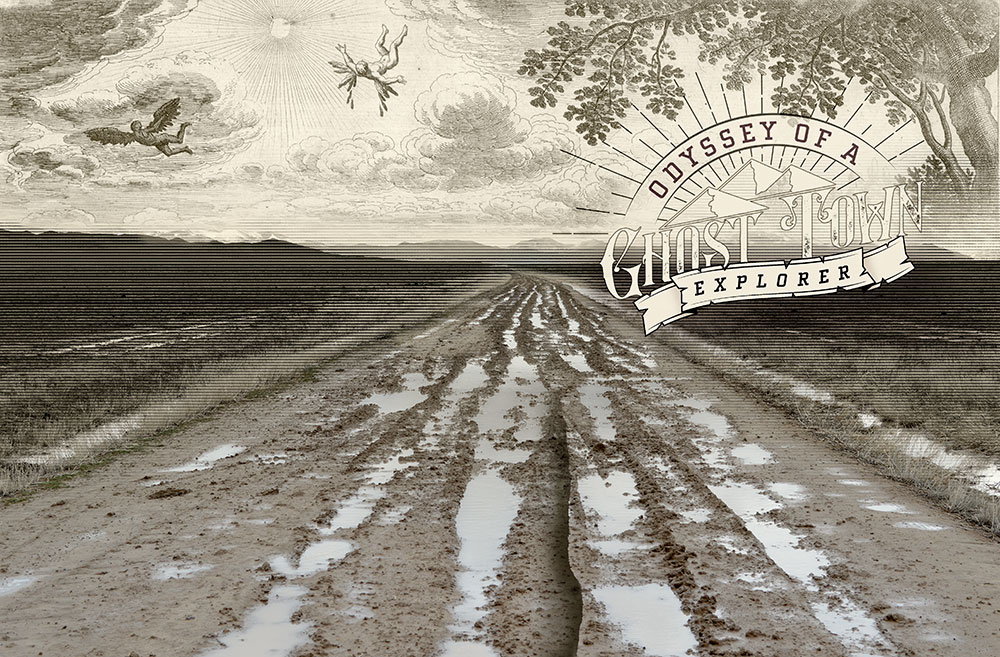
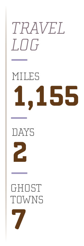
Odyssey of a Ghost Town Explorer: Part 10
July – August 2019
Icarus
STORY AND PHOTOS BY ERIC CACHINERO
Melting wax and burning feathers were likely the last things Icarus, son of the prominent craftsman Daedalus, saw before his body plunged from the sky into the sea. The famous Greek myth tells of how the two characters become imprisoned by King Minos on the island of Crete, banished forever to a tower above the king’s palace. Being the artisan he was, Daedalus crafted two sets of wings using wax and feathers, and the pair used them to fly away, escaping their prison. Before the flight, Daedalus instructed Icarus not to fly too close to the sun, for the heat would melt the wax and send him plummeting into the sea. Icarus, intoxicated on the allure of flight, ignored his father’s advice, flying too high before the sun melted the wax, sending him plummeting into history.
In many ways, the tragic story of Daedalus and Icarus can be compared to the prospectors of early Nevada. They went wherever the silver was no matter the cost, which in some cases, meant climbing higher and higher into the mountains, sometimes building their homes in places they had no earthly business doing so. In the case of Aurum, located high in the Schell Creek Range in eastern Nevada, three prospectors would pay the price like Icarus. Their demise would be an ironic one, though, because it would not be a blazing sun that brought death. Desert snow would deal their death blow.
Wallace McCrimmon, John Fox, and W.H. Mitchell were the three pioneers whose wings would melt on Feb. 11, 1884, when an avalanche crashed into the mining camp of Aurum. The tragedy stands as a reminder that sometimes recklessly flying too high can get you killed.
GLOBAL GLITCH
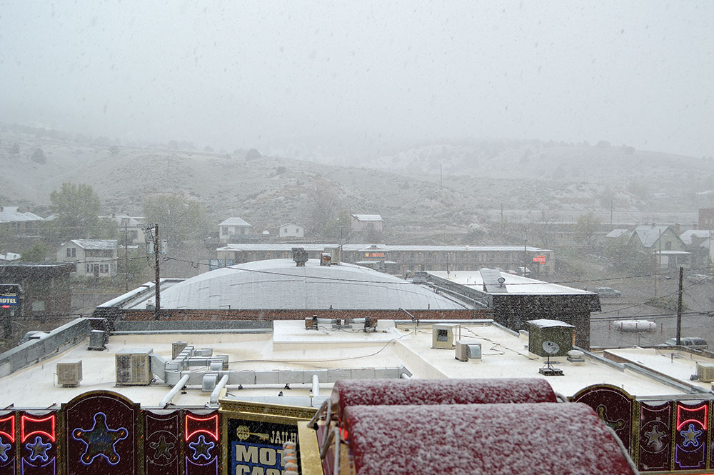
It’s May 21 when I start my ghost town adventure, which means its springtime in Nevada. The birds should be chirping, flowers should be in full bloom, and the sun should be smiling down upon the Silver State. Hotel Nevada in Ely is my ghost town base camp for the trip, and as I open my eyes and peer outside…it’s absolutely dumping snow. I feel like a kid on Christmas morning…only the opposite. I asked Santa for a mountain of presents and a trove of dry roads and easily accessible ghost towns, and I’m greeted with a mountain of coal that I know means soupy mud roads and malicious mountain passes. But, considering I don’t have a choice, I set off into the great and mysterious unknown.
As I drive northbound on U.S. Route 93 out of Ely, I sip my coffee in the company of the radio, orchestrated by a DJ who is as irked by the weather as I am.
“I’m sorry to do this to you, Ely, but here’s the weather report for the next week,” the voice cracks through the speakers. “100 percent chance of snow showers today with a high of 37…Then 100 percent chance of snow showers tomorrow with a high of 38…” The message goes on for a minute or two before the DJ dedicates a song to the town of Ely, and a familiar B.J. Thomas rendition appropriately comes on:
“Raindrops are falling on my head
And just like the guy whose feet are too big for his bed
Nothing seems to fit

Those raindrops are falling on my head, they keep falling…”
The song lightens the mood a bit, and I take the low-hanging fruit first, which in this case means low-elevation ghost towns. Cherry Creek is on the list, and while it doesn’t meet my typical requirements of ghost town, there is a paved road leading all the way to the town, so I head there first.
The reason it doesn’t meet my requirements, is that Cherry Creek is very much a living ghost town with a population of a couple dozen residents. I usually like my ghost towns good and dead; completely without a pulse. But Cherry Creek’s historical significance is undoubted.
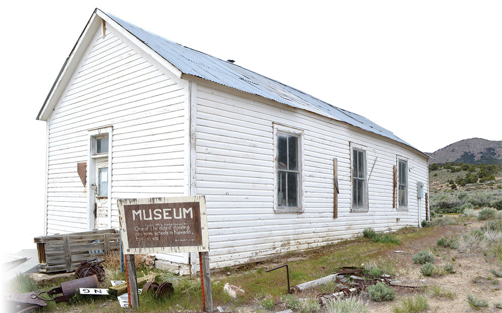
Silver was discovered in Cherry Creek in 1872 by prospectors Peter Corning and John Carpenter, staking the Tea Cup claim. By 1873, about 400 people called the town home. Cherry Creek quickly became the county’s largest mining camp, attracting a Wells Fargo agency and a post office. After a small lull in ore production, the town peaked in 1880 when additional mineral deposits were discovered, bringing a population of more than 1,800. A financial crash in 1883 closed much of the town’s services, and an 1888 fire dealt another deafening blow, as did major fires in both 1901 and 1904. The town held on though, with substantial mining activity well into the 1940s.
Cherry Creek is the very definition of a living ghost town. Homes and trailers are interspersed among buildings in various stages of decay. Remnants of stone buildings dot the landscape, though the highlight of the town is probably the historic one-room schoolhouse. Constructed in 1872, the schoolhouse is one of the oldest in Nevada. History maintains that a dispute over the schoolhouse’s proposed location lead to a deadly gunfight between Cherry Creek residents Pat Green and Pat Dolan, with Dolan the victor.
Though I see several Cherry Creek residents around town, I decide it best not to argue with them over the location of their schoolhouse, and head south toward the nearby mining camp of Egan.
CAVE CREEK
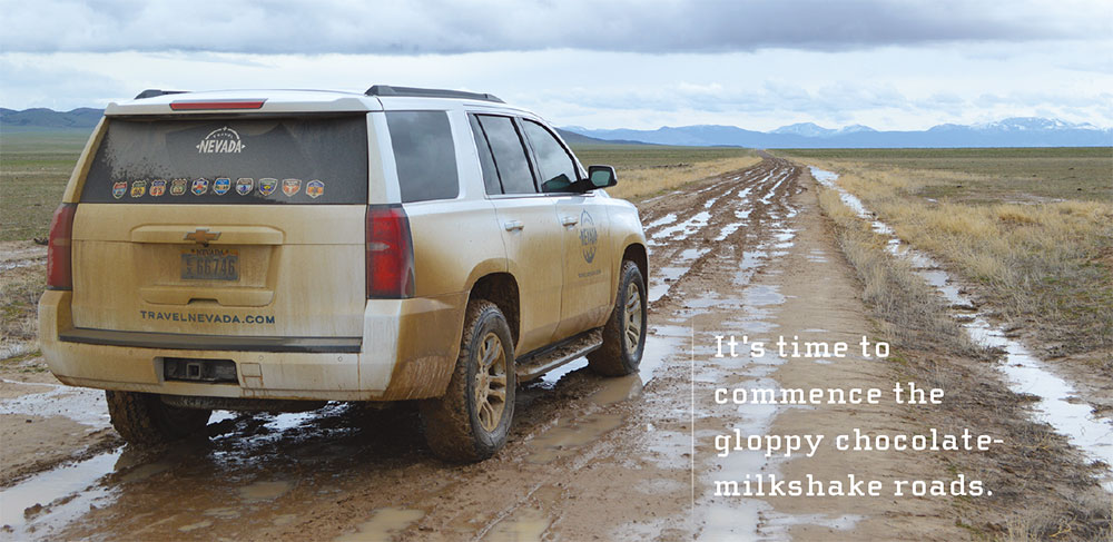
I head up Egan Canyon and am greeted by several wooden structures and an impressive creek. The snow is completely melted at this elevation, which means it’s time to commence the gloppy chocolate-milkshake roads. Though Egan was less of a town and more of a temporary camp, the canyon is special because of its location along the Pony Express route.
The location is named for Howard Egan—a man who pioneered a mail service through the canyon in the 1850s. The west end of the canyon would become home to a Pony Express change station by 1860, and was home to an Overland Mail Company station that would last as a temporary town until 1869.
Unfortunately, I find nothing left of the Pony Express station—an attempt at road building and small mining operations have destroyed the site. The most interesting thing about the canyon, though, is the origin of the aforementioned creek. I follow it to its source, which to my surprise, is flowing from an abandoned mine. Even more to my surprise is way out in the middle of nowhere, I find myself with company. A car has pulled up, and two women exit the vehicle. I’m surprised to see people in such a remote location. We make small talk before the women inform me that the plants growing in the creek water are watercress—an edible aquatic plant. The women quickly fill up several grocery bags with the desert lettuce before hightailing it out of the canyon. I think for a second of trying some of it myself, but considering the source of the creek is coming from an abandoned mine, I decide it best to stick with a handful of trail mix instead.
I head further up Route 93 before turning south to traverse the east side of the Antelope Range. Eventually I find myself leaving the pavement yet again.

SLOP
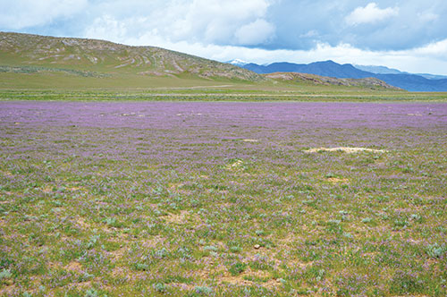 The drive is poetic—true Nevada at its absolute finest. Perfection personified. Graphite rainclouds entwine snow-capped peaks, as they tower above dew-laced rabbitbrush. The rain unshackles the perfume of the sagebrush sea, an intoxicant you can almost taste. Indigo pools of wildflowers splash across the Earth as if placed by intentional brushstrokes. Two golden eagles soar overhead, aiming watchful eyes at the occasional Pronghorn antelope and jackrabbit. There are no natural sounds in this place at this moment; deafening silence is the heartbeat.
I drive further and further into the desert, taking the occasional break to turn off the car and step outside to listen to the atmosphere. With beauty this pristine, it almost seems silly seeking out ghost towns. The roads worsen and worsen, but at first I really don’t care. I need to get further out into this remoteness.
Eventually, though, I snap out of my trance and I realize that it’s the end of the road for me. I had my sights set on the ghost towns of Tippett and Tungstonia, but the snowmelt has made this road impassible, and it’s clear that if I don’t turn around right now, I’ll be spending a cold night out in the desert waiting to be rescued. I decide to try a new road one valley to the west, and the move ends up being a good one.
DESERT AVALANCHE
I find a wide spot in the road to pull over and prepare myself lunch—a freeze-dried pouch of chili mac with beef—before I continue on my newfound dirt road. To my surprise, this new road is in a lot better condition than the last, and I see a glimmer of hope that I may actually get to see some more ghost towns today. As luck would have it, the intermittent slush storms cease just long enough to allow me to climb the craggy road to the townsite of Aurum.
Silver was discovered on the east flank of the Schell Creek Range in 1878, giving rise to a new mining camp called Silver Canyon—later renamed Aurum. By 1881, Aurum had a store, saloon, blacksmith, school, post office, and two boarding houses.
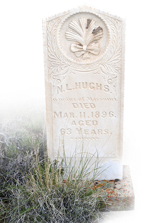
The fateful tragedy of the pioneers that lived in Aurum can be tough to grasp. An avalanche killing people in the middle of the desert does sound like the makings of a “The Twilight Zone” episode, yet it actually happened in Aurum. Last issue, I wrote about how a flash flood claimed the lives of eight people in the mining camp of Mazuma, leading to the realization that maybe water in the desert is a lot deadlier than it’s made out to be.
I find the cemetery at Aurum, and according to an informative plaque at the site, two of the three men that died in the avalanche are buried in the plot, though I can’t find their headstones. Regardless, the cemetery is authentic as can be, with several stones still legible.
IT’S A SIGN
I drive south a couple more canyons before picking a new one to go up, with my sights set on the ghost town of Muncy. My foot, however, takes a lighter approach on the gas pedal as the ominous clues of Muncy start to peak out from behind the bushes. Some “keep out” signs in Nevada leave questions to the person reading them. “How old is that sign? Do you think they mean me? Do they mean just don’t leave the road?” The sign that greets visitors of Muncy, on the other hand, is very clear in its ugly message.
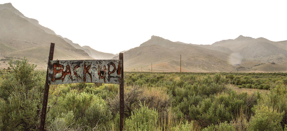
“BACK UP!”
Against my better judgement—and due to how old the sign looks—I do not back up, and instead head further up the canyon. The rain really starts to pour right as I can tell I’ve reached the “townsite.”
Muncy never really amounted to much. Copper mining took place in the canyon above town during the 1870s and 1880s, though nothing significant was ever mined. People continued to mine the district over the decades, though disappointment was largely the only thing uncovered.
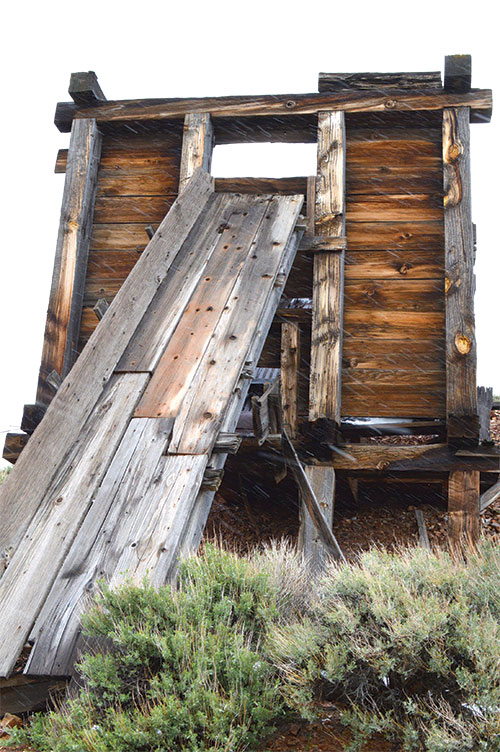
It’s clear as I arrive that most of the structures left in Muncy are probably less than 50 years old, though it appears most of them have roasted in a wildfire. Propane tanks and an old bicycle are some of the only highlights. I press on after exploring briefly.
 WAX AND FEATHERS
Eureka!
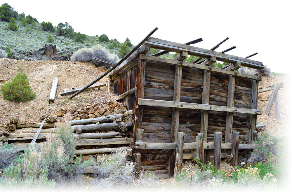
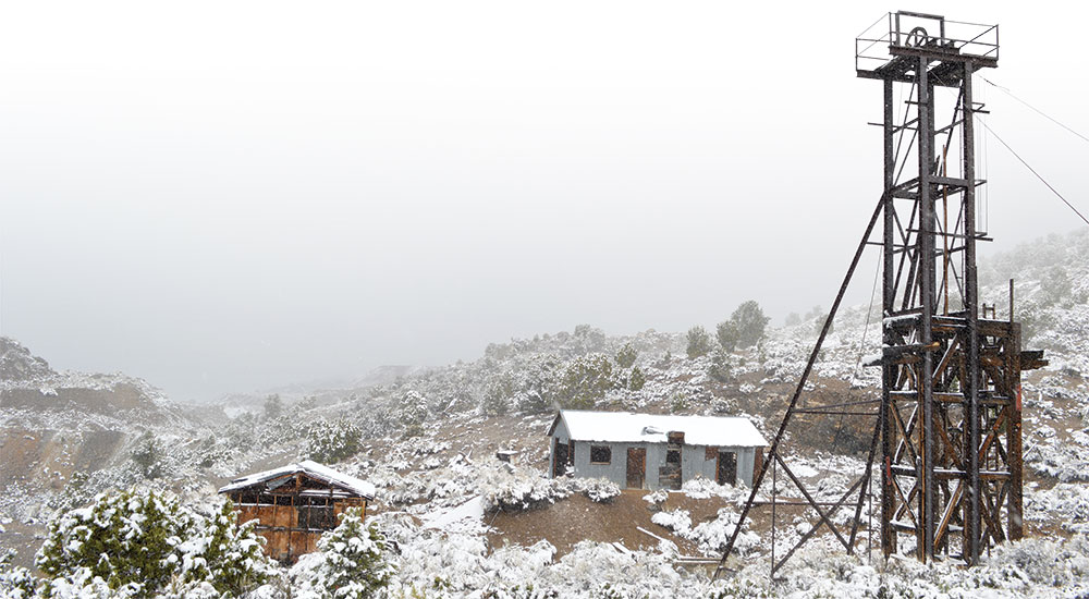
Finally, after a day full of snow, sleet, ice, mud, rain, slush, hail, and every amalgamation thereof, the sun shows itself, though it’s about to set. I make one last push higher and higher into the Schell Range in hopes of reaching the ghost town of Siegel. As my elevation increases, the road becomes rockier and narrower. The higher I climb, the more my tires start to slip and send me sliding into muddy ruts. I think, “What if I get stuck up here?” “How would you ever recover a stuck car up this high?” My questions are answered by the appearance of a collection of rusted old vehicles (ones that weren’t as lucky as me) and a rickety log cabin let me know I’ve reached my objective.
Siegel was originally named Centerville when silver was discovered in the early 1870s and lasted intermittently through the 1880s. In the early 1900s, a Utah financier renewed operations at the camp, though the venture was short-lived.
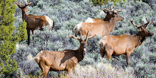
As the sun officially retires, I head back down the hill before I get myself into trouble. I’m greeted with herds of mule deer and Rocky Mountain elk reveal themselves around almost every turn. I make the long trek back to Ely, and am greeted with a massive snow storm when I reach town.
“Raindrops keep falling on my head…”
NEVADA
I’m reminded that Nevada is derived from the Spanish phrase meaning “snow covered” as I awake the next morning to similar conditions. I waste no time heading south out of Ely toward the mining camp of Taylor.
The road to Taylor is unforgiving due to the mud. Again, I climb higher, and again, I am greeted with muck where a road should be. I decide it best to get out and walk to Taylor, due to the fact that I’m just spinning tires at this point.
Taylor slid under the headlines for its first several years of life, though by 1880, the town boomed. Prospectors who folded on Cherry Creek made their way to Taylor, and the town was the county’s top producer for a number of years. Taylor was billed as a quiet and orderly town, boasting an opera house, and was visited by the occasional traveling circus. Production waned due to the up and coming town of Ely nearby, and Taylor slowly faded out over the decades.
I am impressed with the amount of explorable real estate at Taylor. A large headframe and several operations buildings remain. A highlight of the location is the boxes of rock core samples left in one of the buildings. It’s as if everyone simply walked away one day, giving a glimpse into a time and a place reclaimed by history.
BACK UP! SERIOUSLY
I head toward my final ghost town of the trip, located on the western edge of the Snake Range, just northwest of Great Basin National Park. I’d heard good things about Osceola, not only for what remains there, but also for its place in Nevada history.
Osceola lays claim to one of the longest-worked placer camps in Nevada. The town was actively mined from 1872 well into the second half of the 20th century, with small operations continuing today. As impressive as its timespan was its ore production, with the gold-bearing quartz belt measuring 12 miles long by 7 miles wide. The deposit was originally mined by hand using pans and rocker boxes, until a five-stamp mill was built in 1878.
Osceola’s problem was that there was no water to mine with. So, mining interests constructed an 18-mile-long canal to bring water from streams running down the west side of Wheeler Peak, followed by another 18-mile canal to catch water running down the eastern side. The Osceola ditch, as it was called, was an impressive aqueduct that changed how miners recovered the riches. The Osceola Placer Mining Co. became the first in the state to employ hydraulic mining, an incredibly destructive process that employed high-pressure water hoses to wash away the mountainside into sluices to recover gold and silver.
For as incredible as the history of Osceola is, I’m pretty disappointed that not much remains in the public property realm. “No Trespassing” and “Private Property” signs dot nearly every structure—historical and modern—and in many ways deplete the historic value. I do manage to find several old wooden structures to photograph, but they too have the signs splattered across them. It’s a shame in some ways, understandable in others.
After Osceola, I decide I’ve had enough ghost towning for one trip, and I make my way back to Carson City on the Loneliest Road in America.
RAPTURE
Would the pioneers who lost their lives on that fateful day in Aurum regret their ventures? They say space is the final frontier, but before that, the Western U.S. was the final frontier. These men and women were the astronauts of their time, journeying into an unfamiliar and unforgiving moonscape. Sometimes they flew too high and their wings melted, but that’s only one way to look at the story. Irish poet and playwright Oscar Wilde gives us the other.
“Never regret thy fall, O Icarus of the fearless flight. For the greatest tragedy of them all is never to feel the burning light.”