Take the Road Less Traveled
Winter 2021
These Southern Nevada backcountry roads lead to miles of scenery and solitude.
STORY & PHOTOS BY MARK PETTERSON
“I go down every road there is, just to see what’s around the bend.” –From “Around the Bend” by blues guitarist Joe Bonamassa
“Take the road less traveled” is a familiar slogan, but I doubt that it fits anywhere better than the state of Nevada. It could easily be said that “real Nevada starts where the pavement ends.” With thousands of backcountry roads to explore, Nevada travelers could easily never stop searching to find out what spectacular sight is waiting around the bend.
When you were a kid on a family vacation, did you stare out the window of the car, whizz by anaobscure road that led into some intriguing backcountry, and think, “I wonder where that road goes?” I know I did. Unfortunately, growing up in Chicago, my dad’s idea of a vacation was to drive 600 miles a day, stay on the interstate unless absolutely necessary, and spend all of about one hour in a national park. It drove me crazy. Fortunately, now I live in Henderson, and I can get away on the road less traveled easily, and savor the wonders for as long as I want. You can, too. Hundreds of backroads are accessible within an hour from the Vegas area, and the jackpot (to coin a Vegas term) is located in Lake Mead National Recreation Area (LMNRA). The National Park Service has done a marvelous job of designating approved backcountry roads. These are marked with brown signs with a yellow arrow, and a corresponding road number. There are four backcountry road maps; they are available online and at the Alan Bible Visitor Center just east of Boulder City. There is an amazing total of 150 open and/or accessible backroads in LMNRA, and I have been fortunate enough to have explored 143 of them (so far). It was a tough decision, but these are my four favorites.
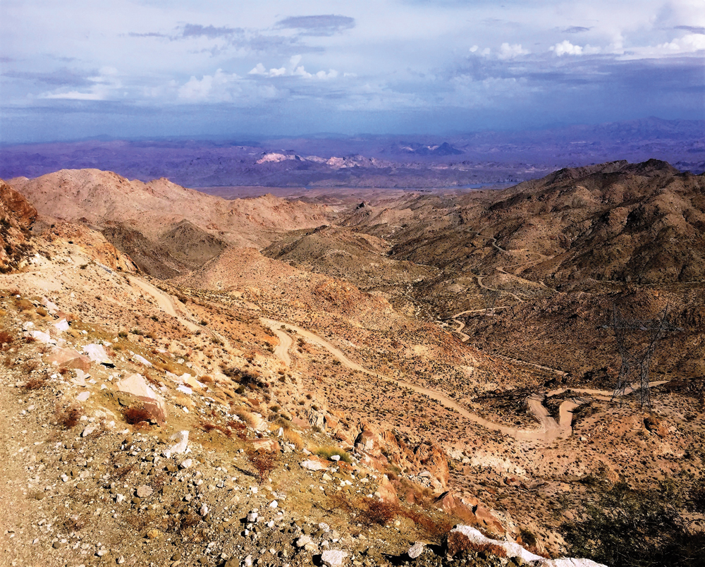
WEST POWERLINE WASH ROAD (LMNRA #42B)
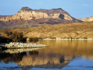
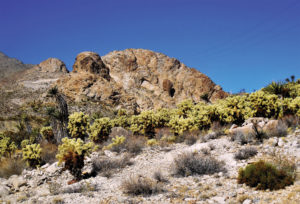
This is my favorite backroad in LMNRA because I find it to be the most spectacular backroad anywhere within three hours of Las Vegas. From its lofty beginning, it drops an amazing 3,600 feet in 12.3 miles to Lake Mohave, which is like being able to drive down approximately two thirds of the average depth of the Grand Canyon. The road itself is an engineering marvel, as it twists, turns, climbs, and dips its way through the tortured jumble of the southern Eldorado Mountains, all while somehow maintaining service access to a dead-straight row of powerline towers. The road features views of incredible geologic features; large, dense stands of teddy bear cholla cacti; many enormous barrel cacti; and in the spring, a variety of beautiful wildflowers. The reward at the end (after the last 2.7 miles on Aztec Wash Road, LMNRA #43) is a gorgeous view of Lake Mohave at a secluded cove, with the powerful and unique profile of Fire Mountain directly across the crystal-clear waters.
The drive: From intersection of I-11 and U.S. 95 (southeast of Las Vegas/Henderson), go south 20.8 miles to a legal crossover just beyond some powerlines. Turn back north for 0.7 miles and turn east on the gravel road. After about 6 miles, you will pass through the “Knob Hill” area, which is like a miniature version of the spectacular rocks in Joshua Tree National Park. The main road weaves its way between amazing rock formations, and you can turn off into the heart of this wonderland of rocks; primitive camping is allowed here. From there, the main road should be evident. Soon the road takes a big bend up and to the right, and be ready for a view that will make your jaw drop. You will see seemingly endless ridges of the Eldorado Mountains below you; portions of the road snaking their way through the hills; and Lake Mohave far, far beyond. And you will probably wonder, “I can drive through all that?” Yes, you can, and believe it or not, this road is well maintained and only a bit rugged in a few places.
About 3.6 miles after the high point (the beginning of the road), there is a beautiful view to the north, through a gap in the rocky crags. This is immediately followed by the most breathtaking portion of the road—a series of switchbacks down a steep hillside. Eventually this road merges with Aztec Wash Road; turn right (east) and head toward Lake Mohave. After taking a rest and enjoying the lovely view (and perhaps taking a dip), backtrack on Aztec Wash Road, and stay on this road (about 6 miles from the lake, Eagle Wash Road branches to the east; go straight here) back to pavement in the tiny town of Nelson. Turn northwest on State Route 165, which will take you back to U.S. 95 and the Vegas area.
CALLVILLE WASH NORTH ROAD (LMNRA #94)

This road offers a veritable all-star collection of spectacular sights and geologic features in its 5.8-mile length. Beginning at the mile marker 16 along Northshore Road, this road runs through backcountry filled with extraordinary layered, twisted, and faulted multicolored sedimentary rocks. It gives the feeling of true wilderness, even though it is never more than about 2 miles from Northshore Road.

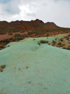
The scenery starts out with a bang, featuring a horned peak with incredible curved, dipping strata. Stay to the left side of the wash, and soon the brilliant red, white, and orange cliffs of the Bowl of Fire come into view; you can park in this area and hike about 1.3 miles up a side wash to the colorful rocks. Just beyond that point is an amazing hillside of lime green volcanic ash. Before long, the wash becomes more like a canyon, and there are many fascinating geologic features, including reddish-brown cliffs laced with a spider web of white gypsum veins. After weaving through the narrow canyon, the road ends at a miniature slot canyon. A short and easy hike provides textbook evidence of the deposition and subsequent erosion of the strata.
The drive: From the Las Vegas area, head east till you reach Northshore Road (State Route 167). When you reach mile marker 16, the trail is just north of Northshore Road.

CHRISTMAS TREE PASS ROAD (LMNRA #20)
 This road offers spectacular and diverse scenery; it is one of the few backroads that is usually suitable for a carefully driven sedan; it leads to areas of historical significance; it can be done as a loop instead of an out and back; and it provides convenient access to other excellent backroads.
The drive: From the Las Vegas area, take U.S. 95 south past the tiny town of Cal-Nev-Ari, and turn east at the signed Christmas Tree Pass Road. The road climbs into a beautiful pinyon-juniper woodland as it reaches the Newberry Mountains. The high peak to the northeast is Spirit Mountain, which is considered as the center of creation by local Native American tribes. Then the terrain transitions from a wooded area to a wonderland of spectacular granite spires and pinnacles. Near the south end of the road, you can turn west to access the Grapevine Canyon petroglyphs, which are arguably the most impressive collection of Native American rock art within two hours of Las Vegas. After a very short drive on the spur road, a 0.3-mile hike leads to the heart of the petroglyphs.
From there, it is only 1.8 miles south to State Route 163. At this point, you can turn west and follow S.R. 163 through some beautiful mountains back to U.S. 95, before heading back north to the Vegas area. Or you could turn east, go 1.7 miles, and turn north on Nevada Telephone Cove Road (LMNRA #9), which leads to a lovely beach on Lake Mohave, as well several other great backroads.
BOY SCOUT CANYON ROAD (LMNRA #59)
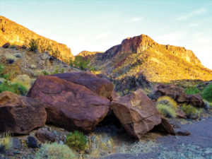
This road is fairly close to town; it is short and not particularly rough; it packs a lot of beautiful sights into its 3-mile length, and there are three awesome side canyons to hike through at the end of the road. Located just south of Boulder City, this road passes through a corridor in the Black Canyon Wilderness. It is flanked by soaring basalt cliffs (the edge of an ancient lava flow) on one side, and by rugged mountains on the other. The road winds between fascinating, multi-colored rock formations with hundreds of enormous basalt boulders which have tumbled into the canyon. At the end of the road the “main canyon” continues northeast past a cable barrier; from there you can hike 1.8 miles down a gorgeous canyon to a view of the Black Canyon of the Colorado River. Another virtually unknown canyon runs due north; it is rugged, narrow, and quite spectacular. A third canyon runs west and is also very scenic. After you turn around, the ragged edge of the lava flow is now directly in front of you, and on spring or summer evenings, these cliffs appear to ignite in the warm glow of the low sun, seemingly becoming molten lava again.
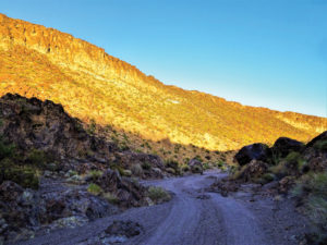
The drive: Take Buchanan Blvd. south from the intersection with U.S. 93 in downtown Boulder City. Turn east on Adams Street, then south on Utah Street. Turn right at the sign for the shooting range and follow the pavement to a gravel road with an orange sign reading “Canyon Point.” After 0.3 miles from there, go straight where the main road bends to the right. Descend the hill, and after about 1.5 miles, you will enter the the canyon. The sinuous stretch after about 2 miles is quite narrow, and probably the most exciting section of the road.
RESPECT PUBLIC ROADS
When you are traveling in the Nevada backcountry, please respect and don’t disturb the land or the wildlife; adhere to the principles of Leave No Trace; be prepared with a dependable, high-clearance vehicle (preferably 4WD); bring along essentials (especially a good spare tire, and plenty of fuel and water); and always stay on the designated roads. Do not travel on any backroad if rain is in the forecast. Tell someone of your travel plans, and don’t depend on cellphone coverage. On LMNRA backroads, call the LMNRA office at 702-293-8990 to verify road conditions.